Sunday, March 7, 2010

Natural Bridge Canyon, Death Valley

Natural Bridge Canyon is found on the east side of the park and is one of the few canyons with an official trailhead. The canyon contains a natural stone bridge.

Mosaic Canyon, Death Valley

Mosaic Canyon is a canyon in the north western mountain face of the valley which is named after a stream-derived breccia sediment with angular blocks of dolomite in a pebbly matrix. The entrance to Mosaic Canyon appears deceptively ordinary, but just a 1/4 mile walk up the canyon narrows dramatically to a deep slot cut into the face of Tucki Mountain. Smooth, polished marble walls enclose the trail as it follows the canyon's sinuous curves. The canyon follows faults that formed when the rocky crust of the Death Valley region began stretching just a few million years ago. Running water scoured away at the fault-weakened rock, gradually carving Mosaic canyon.


Our Google Map Location

Saturday, March 6, 2010

Mesquite Sand Dunes, Death Valley

The Mesquite Sand Dunes are at the northern end of the valley floor and are nearly surrounded by mountains on all sides. Due to their easy access from the road and the overall proximity of Death Valley to Hollywood, these dunes have been used to film sand dune scenes for several movies including films in the Star Wars series. The largest dune is called Star Dune and is relatively stable and stationary because it is at a point where the various winds that shape the dunes converge. The depth of the sand at its crest is 130-140 feet but this is small compared to other dunes in the area that have sand depths of up to 600-700 feet deep.
The primary source of the dune sands is probably the Cottonwood Mountains which lie to the north and northwest. The tiny grains of quartz and feldspar that form the sinuous sculptures that make up this dune field began as much larger pieces of solid rock.
In between many of the dunes are stands of creosote bush and some mesquite on the sand and on dried mud, which used to cover this part of the valley before the dunes intruded.


In this photo you can see how big the dunes are, that is Jane walking on the ridge


Our Google Map Location

Badwater Basin, Death Valley National Park California

282 feet below sea level… Dang! Badwater Basin is an endorheic basin in Death Valley noted as the lowest point in North America, with an elevation of 282 ft below sea level. The site itself consists of a small spring-fed pool of "bad water" next to the road; the accumulated salts of the surrounding basin make it undrinkable, thus giving it the name. The pool does have animal and plant life, including pickleweed, aquatic insects, and the Badwater snail. Adjacent to the pool, where water is not always present at the surface, repeated freeze–thaw and evaporation cycles gradually push the thin salt crust into hexagonal honeycomb shapes.


This is the view back towards the parking lot. It’s real hard to see but half way up the mountain is the sea level line. It’s hard to put this place in perspective, it’s so large. You can’t even tell there is a parking lot full of cars and rv’s.


Our Google Map Location


Friday, March 5, 2010

Artist Drive, Death Valley National Park California

Artist Drive is a scenic loop drive through the fantastically colored clay and mudstones of the Artist's Drive Formation. These ancient volcanic ashfalls have been weathered by time and hot groundwater into clays of every color from pale aqua blue-green to rich carmine red.


Our Google Map Location

Mojave National Preserve, California


We headed to Mojave Desert via Route 66. The Mojave is an expansive desert that seems to go on forever. We stopped at the Kelso Depot for lunch and a break from the long desert highway.


A train passed Kelso Depot that must have been 2 miles long, it had four engines in front and one in the rear.


Our Google Map Location

Joshua Tree National Park, California

Joshua Tree National Park

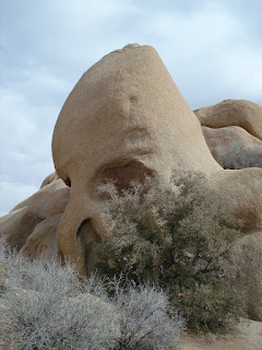
The higher, drier, and slightly cooler Mojave Desert is the special habitat of the Joshua tree from which the park gets its name. In addition to Joshua tree forests, the western part of the park includes some of the most interesting geologic displays found in California's deserts. The dominant geologic features of this landscape are hills of bare rock, usually broken up into loose boulders. These hills are popular amongst rock climbing and scrambling enthusiasts. The flatland between these hills is sparsely forested with Joshua trees. Together with the boulder piles and Skull Rock, the trees make the landscape otherworldly. Five Washingtonian fan palm oases in the park are the few areas where water occurs naturally and wildlife abounds.


The name Joshua tree was given by a group of Mormon settlers who crossed the Mojave Desert in the mid-19th century. The tree's unique shape reminded them of a Biblical story in which Joshua reaches his hands up to the sky in prayer. Ranchers and miners who were contemporary with the Mormon immigrants also took advantage of the Joshua tree, using the trunks and branches as fencing and for fuel for ore-processing steam engines.


Skull Rock


We had to move this boulder to get to the rest of the trail.

Cholla (Choy -a) Cactus

The small round cactus pieces you see on the ground, are called jumping teddy bears. These Cholla cactus seeds, they fall to the ground and are moved by wind or animals till they take root.

Ocotillo
The ocotillo is a curious and unique desert plant of the southwestern United States and northern Mexico. For much of the year, the plant appears to be an arrangement of large spiny dead sticks, although closer examination reveals that the stems are partly green. With rainfall the plant quickly becomes lush with small ovate leaves, which may remain for weeks or even months.


Our Google Map Location